mtholton
5 year old buck +
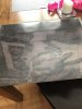
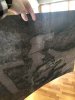
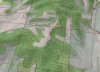
I have a few volunteers willing to help plant trees this spring and wanted to be able to point out planting locations since there will be multiple planting sites going in at the same time. I map a large laminated map to help out. Directions below. Turned out pretty good.
I used google earth pro to download a high res map of my land. Make sure to use highest res in the settings. If you haven’t used it before it’s worth downloading. A neat feature is that you can look at prior year satellite views as well. It allows you to see your property in different seasons. You can also overlay elevation and adjust the opacity. You can also change the view angle which helps show elevation. I used vista print to print two maps - a larger area view of my land and a close up of the property. 18 x 24 size. 9 bucks for that size. I purchased self laminating paper. Scotch Single-Sided Laminating Sheets, 9 x 12-Inches, Letter Size (LS854SS-10) https://www.amazon.com/dp/B0013C7V24?ref=yo_pop_ma_swf . Now I can use a dry erase marker to show work areas etc. Figure we can hang on wall in camp to point out stands etc in the future. Should get the job done for 20 bucks. If I do it again, I’ll bring it into a office supply store to get it professionally laminated. The sheets aren’t perfect I had some bubbles and overlap. Aside from that it should serve its purpose. Next round I’ll do an elevation overlay as well.
I used google earth pro to download a high res map of my land. Make sure to use highest res in the settings. If you haven’t used it before it’s worth downloading. A neat feature is that you can look at prior year satellite views as well. It allows you to see your property in different seasons. You can also overlay elevation and adjust the opacity. You can also change the view angle which helps show elevation. I used vista print to print two maps - a larger area view of my land and a close up of the property. 18 x 24 size. 9 bucks for that size. I purchased self laminating paper. Scotch Single-Sided Laminating Sheets, 9 x 12-Inches, Letter Size (LS854SS-10) https://www.amazon.com/dp/B0013C7V24?ref=yo_pop_ma_swf . Now I can use a dry erase marker to show work areas etc. Figure we can hang on wall in camp to point out stands etc in the future. Should get the job done for 20 bucks. If I do it again, I’ll bring it into a office supply store to get it professionally laminated. The sheets aren’t perfect I had some bubbles and overlap. Aside from that it should serve its purpose. Next round I’ll do an elevation overlay as well.