Uncatagorized.....things we see....

Bill How far is a canyon run one way How deep is it and the main species you fish for there. How big is your boat.
IMG_4722.jpeg
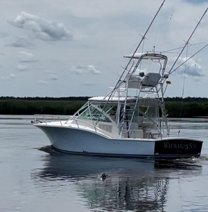
It’s what they call a sportfish. But the guys with 70’ foot sportfish boats would call it a dingy. 32 foot Carolina Classic dual 6.7 Cumins engines.

Our closest canyon is 65 miles from the inlet so minimum 130 miles round trip which doesn’t include trolling time while we fish. Depth goes from 0 at the beach. 25 foot channel going out. 65 miles out it’s 400 to 500 feet deep. The canyons are like the Grand Canyon under water. Goes from 500 foot deep to 1500 and beyond in no time.
The main target is yellowfin tuna or white Marlin.

But we’ve been wasting time targeting bigeye tuna. Small chance of catching one. But awesome when you do.
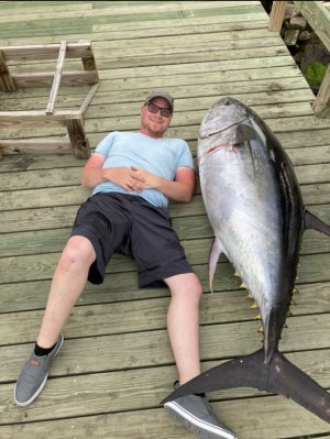
IMG_0629.jpeg

We used to try day trips but they don’t really work. Like deer the best time to hunt is dawn and dusk. Used to leave the dock at midnight, fish the Am and try to be home before dark. Learned to leave at 10 AM fish dusk. Drift and sleep. Fish the dawn and day then come home before dark.

It’s a grind when you come home empty. But like deer hunting it’s unbelievable when you actually make it happen.
 
Also. 23 knots optimum speed. So it’s 3 hours to the closest fishing and 3 hours home.

I usually drive home alone while everyone else is sleeping on a marine bean bag.
 
Drift and sleep 65 miles out in the ocean 😱. I'd be afraid to wake up on the other side of the world 😁
 
Drift and sleep 65 miles out in the ocean 😱. I'd be afraid to wake up on the other side of the world 😁
😄 Actually don't drift too far. If it's really windy you can't be out there because wind makes waves.
 
Does the boat have sleeping quarters, or have you ever spent the night on it?
 
Does the boat have sleeping quarters, or have you ever spent the night on it?

There is a bed down below but we just sleep on bean bag chairs in the helm area and down below. The bed is usually coved up in tackle.
 
How much fuel do you burn on a typical trip? (I wont report you to Al Gore...lol)
 
How much fuel do you burn on a typical trip? (I wont report you to Al Gore...lol)
Boat holds 350 gallons. Shortest canyon trip was about 180 gallons. The longest we’ve done was 300 gallons. I’ve threatened getting a 75 gallon bladder tank so we can go further if the fish are out of range. Just haven’t pulled the trigger on that one yet. Weather permitting we only get about 8 trips a summer. This past summer the weather was awful. Only made it 5 times. We split the cost 4 ways most of the time.

Like I said earlier, I don’t know how charter boats can turn a profit.

Al Gore knows about us. There is a 10 knot speed limit from shore to 100 miles out for boats over 100 foot long most of the year. (To save wales that no one ever hits) The Biden admin wanted to expand that to boats 35 foot and over. It would shut most guys down. 6 hour drive one way to fish would be grueling.
 
I've never considered the speed limits and that you had to go so far to fish. That makes for a long trip for certain. Lot's of preparation for a trip like that.

Bill, I know you've posted this before......but where do you sail out of?
 
I've never considered the speed limits and that you had to go so far to fish. That makes for a long trip for certain. Lot's of preparation for a trip like that.

Bill, I know you've posted this before......but where do you sail out of?

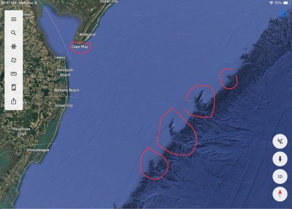
Cape May, NJ. All the way at the bottom of the state where people are still sane.
IMG_7490.jpeg

Oh wait wrong pic. Here is where we leave from and go to.

IMG_7489.jpeg
 
Bill that's awesome I am impressed how those fish utilize those cuts in the bottom that I'm sure funnel surface current which piles up baitfish. I fish a spot in lake michigan that drops from 160 to 410 in three miles. There are always salmon and trout there 13 miles out
 
My FL experiences are not good. High traffic everywhere.....gotta make restaurant reservations days in advance. Crazy busy place. Over priced everything. Tourist traps. Too many snooty east coast people. Humidity. Bugs. Hurricanes.....and expensive. You really cannot use the ocean or afford to live on the ocean.....just look at it....if you can park 1/2 mile away at a meter and lug a cooler and chairs to watch the sun go down (big whoop). Yadda Yadda.
Yea, that's not for me either. I'm on Lake Okeechobee most of my days, when I'm not hog hunting. There are more local cowboys than New Yorker's where I am. Small town atmosphere, that's a little too red-neck for most, if anything. Pretty affordable, as well. Not much fine dining here, but that's not my thing. I can be on the east coast in 30 min and the west coast in 90 min, if I feel the need.
 
Yea, that's not for me either. I'm on Lake Okeechobee most of my days, when I'm not hog hunting. There are more local cowboys than New Yorker's where I am. Small town atmosphere, that's a little too red-neck for most, if anything. Pretty affordable, as well. Not much fine dining here, but that's not my thing. I can be on the east coast in 30 min and the west coast in 90 min, if I feel the need.
When people tell me about the ocean and the beaches.......That is when Florida turns me off. Most folks cannot really use the ocean front.....unless you wanna pay out big time. Even then.....not for me.
 
And then comes hurricane I am gonna cause billions of dollars of damage and all who live near there are gonna pay insurance rates through the roof. Then we're gonna rebuild and do it all over again. It's the same as living on a flood plane hmmm 20 inches of rain and it floods. I wonder what might happen
 
Bill I'm curious where you got the map of the ocean showing those cuts off the shelf.
 
Bill I'm curious where you got the map of the ocean showing those cuts off the shelf.

Google earth app.
 
Google earth app.
Bill, how deep is the water at the top of those drop offs? Approximately? Not familiar with ocean depths.
 
Bill, how deep is the water at the top of those drop offs? Approximately? Not familiar with ocean depths.
350 to 500 then you go off the cliff and get to 2000 and deeper fast. Matic is correct the fish corner bait against those walls and smash them. Bait rises as the sun falls and disperses on the top. As the sun gets higher the bait groups back up and goes deep. Yellow fin tuna are caught in the shallower areas where the ridges are and inside the bank. Bigeye and Marlin cruise the deep. All dependent on water temperature and temperature breaks and color changes of blue and green water.

There are swordfish down there too. Haven't learned how to daytime deep drop for them yet. We know the basics but there is a knack to it. They say once you do it a couple times it's easy. We're not there yet. Maybe next summer. Also the lobstermen set traps in those rugged edges. Later in the summer the Mahi are under the lobster pot buoys. We always see pilot wales (big 20' 2000 lbs dolphins) and big two tone dolphins. Never know what you might see out there. Like I said it gets in your blood.😉
 
Bill I am glad you understand this about current l. In lake michigan I have saw 20 degree surface temperature swings on the surface from upwellings. Kings were stacked in there eating alewife. Their called scum lines but in effect its warm water fighting cold water for dominance. Warm water moves faster than cold water. I am curious about the current where your at and the temperature breaks associated with it. Gotta say I would luv to be on the boat to see how the current runs out that far. Fishing offshore on lake michigan is my favorite like 8 to 15 miles out. Your right on the bait. They do move down in the morning and rise at night. But I wonder if that is the same as plankton in which they eat. Bill any pics of your catches please share and if you have any surface water currents. Ty
 
Bill I am glad you understand this about current l. In lake michigan I have saw 20 degree surface temperature swings on the surface from upwellings. Kings were stacked in there eating alewife. Their called scum lines but in effect its warm water fighting cold water for dominance. Warm water moves faster than cold water. I am curious about the current where your at and the temperature breaks associated with it. Gotta say I would luv to be on the boat to see how the current runs out that far. Fishing offshore on lake michigan is my favorite like 8 to 15 miles out. Your right on the bait. They do move down in the morning and rise at night. But I wonder if that is the same as plankton in which they eat. Bill any pics of your catches please share and if you have any surface water currents. Ty

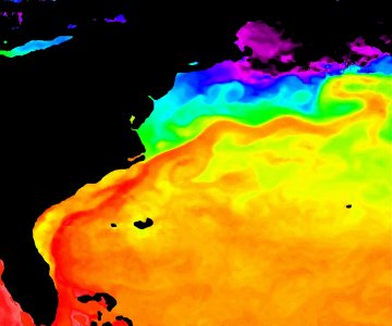
I’ll dig some stuff up to explain it better. We may have start a new thread so we don’t bother everyone :). We follow the the Gulf Stream.


IMG_4733.jpeg

Gulf Stream always flows north. It’s the deep orange. But it ebbs and flows inshore and offshore and when god is on our side we get an eddy. (Eddy is an underwater hurricane that spins hot water inshore).

Currents inshore of the Gulf Stream flow south. Until wind and weather interfere.

If you follow weather patterns over ground we have high and low pressure systems that push air all over the country. Same thing in the ocean water except science hasn’t been able to predict where and why yet in the ocean. When a system breaks a piece of that Gulf Stream off and sends it to a canyon you better be fishing right on the break.

You mentioned current. A temp break at sea surface might not be everything you need. If I find a 5 degree break at the surface I’m fishing the hot side. When I don’t catch there I move the cold side. Current on top sometimes distorts where the real break is down 50 foot.

You mentioned upwellings. Wish I could figure out how to find them in the ocean. I’d pay to fish an upwelling over a temp break anytime.
 
Top