Resolving a discrepancy between plat book and "actual" acreage for a potential purchase

It is odd how different each state does things, I have only bought 3 properties in my life and all 3 are here in NY. With each purchase the seller had the land surveyed prior to selling it, this could have just been weird circumstances but to me it seemed like the seller is required to do a survey prior to the sale. I haven't sold land here yet so I don't know that for sure, maybe others on here from NY could verify or debunk that theory.
 
Bought land in NY without survey this year. Deed referenced county tax maps.
 
When I have worked with survey teams in the past - what you think they do is walk around in the woods measuring things and looking for markers. That’s only a small portion of there job. What they mostly do is spend hours in the town office researching deeds and legal documents. That’s why it costs so much.
 
I don't understand why folks what a survey has to do with calculating the acreage of a property. The deed defines the property. As long as the deed is clear, start at point x, travel x distance at y bearing, repeat until you arrive at the starting point. This defines an irregular polygon. Don't you simply mathematically divide it into a set of regular polygons, calculate the acreage of each and add them all up. Isn't that the acreage of what you own? Doesn't a survey simply superimpose that irregular polygon on the surface of the earth? Except for factoring in the curvature of the earth on very large tracts, I presume the calculation error is a couple of decimal points.

I certainly understand how the imagery issues require georectification as we flatten an image, remove lens effects and stuff. I don't expect any of those systems to accurately represent where a property boundary is. That is where I see surveying coming into play.

Now, I understand if you have some original deed that does not include starting point, distance, and bearing and uses natural boundaries how large discrepancies occur.
You are clearly smarter than I, and I’m not trying to be an ass, my mind was scrambled reading your first paragraph.
My desire to obtain a survey is to define my borders. Currently all I have to go on is a deed I’m not skilled enough to transpose onto the actual land, a county tax map and onx. The problem is the 3 don’t jive. The deed says one thing (306 acres), the tax map shows the same acreage (306) written but among its borders is 14 acres less (approximately 292 per my rough mapping tool skills) and onx is showing the same border (which is where I assume they obtain all their borders) and less land (292) when you click on my tract. So as you can see I either want my 14 acres to hunt and manage or I want to know where the discrepancy in the deed lies as that is a legal document and the others are not.
I was not referring to your post in particular. I realize there are several tangents in this thread. I was back referring to the OP where his concern was whether he will be taxed on the actual amount of acreage he owns. I was trying to distinguish two concepts that can be blurred in some deeds/plats.

The first concept is "How much acreage do I own?" That is defined by the deed. In most deeds it is clear with the description of an irregular polygon with point, distance and bearing description. Other cases where it is defined by natural borders, things become more confused and the acreage may be related to a survey as natural boundaries, like a creek, change course over time.

The second concept is "Exactly where is that acreage located?". That is where a survey is applied to the deed, translating that description to actual pins on the ground.

My farm does not match the county tax map either. Those are just approximations in terms of where the lines appear. In my case, the shape of the property isn't even right. However, the acreage in the tax database matches my deed as it should.

I say all this acknowledging that different jurisdictions handle things differently, so this is a generalization. I'm sure there are some exceptions to the general rule.

Thanks,

Jack
 
It is odd how different each state does things, I have only bought 3 properties in my life and all 3 are here in NY. With each purchase the seller had the land surveyed prior to selling it, this could have just been weird circumstances but to me it seemed like the seller is required to do a survey prior to the sale. I haven't sold land here yet so I don't know that for sure, maybe others on here from NY could verify or debunk that theory.
I don’t think there is any requirement to do a survey. I have bought and sold several plots of land without a survey. On one parcel the buyer had to have it surveyed to get financing, nothing on my end , he paid. I will note that on that particular property I had gone over the deed many times and found all the pins that were still there and marked ones that were not with flags and posts. All lines were flagged with tape. When it was eventually surveyed I was dead on everything so you can get pretty close if you put in the effort reading the deed. That was on 130 acres.
 
I am confused about the confusion and will either clarify or add to it. It's a difficult subject to address in the brief time available. Let's start by understanding there are two different land records systems in play. I only have some understanding about how the two play together - or not - here in Virginia. I would add that I do a lot of things, but playing inside the lines is one of my many vocations. An individual county here is the holder of both sets of records. The land deed containing the property description and a legal survey of the described property, if there is one, are recorded in the land records system. That's one function in a county. The other is the collection of real estate taxes and, until recently and only in part, are the two synchronized - maybe.

You need to understand some history to understand where we are and why there are discrepancies. First, they have been two separate departments each with their very own missions.

Prior to about 2010 ownership and acreages for tax purposes were held as data in a table. And separately and apart there were CAD created paper tax maps. I liken those maps to a schematic. Given the available technology they were adequate for seeing who owned what in an area. The tax maps may have been based on some loose interpretation of deeds or may have been accepted as offered. These tax maps span a hundred years give or take. The only concern of the county real estate assessors office was to fund county operations. If you were taxed on 125 acres- yes, acres ae important for this purpose - you could dispute the acreage if you believed it different. If you thought you had only 110 acres and could verify this then the acreage in the tax table was changed and maybe the paper tax maps was changed -but I doubt it. It was expensive to create a new set of tax maps.

Along comes new GIS technology and the counties - and here in Virginia the state says hey wait a minute. We need to digitize those crudely drawn tax maps and join the tax table to it. The process was a nightmare. One county i am intimately familiar with found they had 11,000 parcels in the tax table and when the paper maps were converted there were 17,000 parcels. Reconciliation went on for years. Today there are 3 counties in Virginia that refuse state funding to digitize the old paper maps and cleanup and match the tax table data to the GIS create tax parcels. They know their tax records are faux pas.

Today, the integration of deeds, surveys, and tax parcel is better going forward, but most counties have no interest in going backwards. And what about deeds and their descriptions? I'm not a surveyor but I know several. I question them about this. Most don't understand GIS and projection systems and how their survey results are translated into a GIS system. Todays experts can account for all of that. As I understand it, surveys are done by assuming a flat plane. On the Earth elevation changes when taken into account will produce a slightly different acreage, but its inconsequential for small areas...but it's a factor. When you look at aerial imagery on something like Google Earth the imagery has been corrected from a flat surface to one that accounts for elevation changes. Now, I'm a little fuzzy on this, but in some cases - with some surveys done years ago the survey plat is created using only the deed information for the property being surveyed. There's no attempt to edge match the determined property boundary with the adjacent property boundary. Today it might be, but I'm not sure.

One example and I'll stop adding to the confusion. Recently the National Park Service (National Battlefield Park Division) was gifted a farm property next to a friend's farm. The friend swears the survey commissioned by NPS takes some of his land. His farm was surveyed by his grandfather back in the 1940's. I went to the county courthouse and for the princely sum of $2 I got a copy of both deeds and surveys. The old survey was simply a written description. No map. It was done in metes and bounds, distances measured in chains and links. The NPS survey was quadrant bearing, distances in feet, Virginia State Plane South. I don't think the metes and bounds survey gave the coordinate system used.

I rolled up my sleeves and used GIS processes to put both surveys on a GIS map. I'm no expert at such things but I pretty damned good at it. Guess what? The edges of the two adjoining properties don't match. There's an overlap of between 20 and 50 feet that amounts to about 20 acres, maybe? I readily admit some of that might be because of my inexperience with such things, but my experience tells me it is possible.

Now - ONX. They simply hijack the county tax parcel information readily available in the public domain. They take that free information, put it in an app and sell it to you. If you have a beef with their "ownership" information you probably have or had a beef with the county where the land is located. A county might update their records but ONX probably won't update yours without paying a new fee.

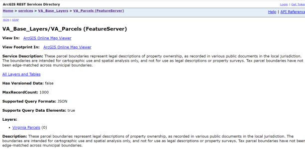
Just to prove a point (I don't remember which one!) copy this link and drop it into Google Earth. Bam! You have all the digitized tax parcels in Virginia...

https://gismaps.vdem.virginia.gov/arcgis/rest/services/VA_Base_Layers/VA_Parcels/FeatureServer
1660097313214.png
 
Surveys and research are important all the time but even more so if close to a county line,river or other major geographic changes.I found a deal a couple months ago where several of the mile sections along the county line were several hundred feet short of a mile.It ended up being a correction line.I also had an instance on my farm where the neighbors line was different when my surveyor got to it.Come to find out it had to be surveyed from the south due to the river the section was also short but it wasn't on my end it was on the neighbors so his half mile wasn't a half mile was something like 25ft off.
 
I always drive an upside down T post at the pins and if the pin is back in the timber I drive an upside down at the pin and a regular one out at the edge of timber and note on survey sheet
 
I am confused about the confusion and will either clarify or add to it. It's a difficult subject to address in the brief time available. Let's start by understanding there are two different land records systems in play. I only have some understanding about how the two play together - or not - here in Virginia. I would add that I do a lot of things, but playing inside the lines is one of my many vocations. An individual county here is the holder of both sets of records. The land deed containing the property description and a legal survey of the described property, if there is one, are recorded in the land records system. That's one function in a county. The other is the collection of real estate taxes and, until recently and only in part, are the two synchronized - maybe.

You need to understand some history to understand where we are and why there are discrepancies. First, they have been two separate departments each with their very own missions.

Prior to about 2010 ownership and acreages for tax purposes were held as data in a table. And separately and apart there were CAD created paper tax maps. I liken those maps to a schematic. Given the available technology they were adequate for seeing who owned what in an area. The tax maps may have been based on some loose interpretation of deeds or may have been accepted as offered. These tax maps span a hundred years give or take. The only concern of the county real estate assessors office was to fund county operations. If you were taxed on 125 acres- yes, acres ae important for this purpose - you could dispute the acreage if you believed it different. If you thought you had only 110 acres and could verify this then the acreage in the tax table was changed and maybe the paper tax maps was changed -but I doubt it. It was expensive to create a new set of tax maps.

Along comes new GIS technology and the counties - and here in Virginia the state says hey wait a minute. We need to digitize those crudely drawn tax maps and join the tax table to it. The process was a nightmare. One county i am intimately familiar with found they had 11,000 parcels in the tax table and when the paper maps were converted there were 17,000 parcels. Reconciliation went on for years. Today there are 3 counties in Virginia that refuse state funding to digitize the old paper maps and cleanup and match the tax table data to the GIS create tax parcels. They know their tax records are faux pas.

Today, the integration of deeds, surveys, and tax parcel is better going forward, but most counties have no interest in going backwards. And what about deeds and their descriptions? I'm not a surveyor but I know several. I question them about this. Most don't understand GIS and projection systems and how their survey results are translated into a GIS system. Todays experts can account for all of that. As I understand it, surveys are done by assuming a flat plane. On the Earth elevation changes when taken into account will produce a slightly different acreage, but its inconsequential for small areas...but it's a factor. When you look at aerial imagery on something like Google Earth the imagery has been corrected from a flat surface to one that accounts for elevation changes. Now, I'm a little fuzzy on this, but in some cases - with some surveys done years ago the survey plat is created using only the deed information for the property being surveyed. There's no attempt to edge match the determined property boundary with the adjacent property boundary. Today it might be, but I'm not sure.

One example and I'll stop adding to the confusion. Recently the National Park Service (National Battlefield Park Division) was gifted a farm property next to a friend's farm. The friend swears the survey commissioned by NPS takes some of his land. His farm was surveyed by his grandfather back in the 1940's. I went to the county courthouse and for the princely sum of $2 I got a copy of both deeds and surveys. The old survey was simply a written description. No map. It was done in metes and bounds, distances measured in chains and links. The NPS survey was quadrant bearing, distances in feet, Virginia State Plane South. I don't think the metes and bounds survey gave the coordinate system used.

I rolled up my sleeves and used GIS processes to put both surveys on a GIS map. I'm no expert at such things but I pretty damned good at it. Guess what? The edges of the two adjoining properties don't match. There's an overlap of between 20 and 50 feet that amounts to about 20 acres, maybe? I readily admit some of that might be because of my inexperience with such things, but my experience tells me it is possible.

Now - ONX. They simply hijack the county tax parcel information readily available in the public domain. They take that free information, put it in an app and sell it to you. If you have a beef with their "ownership" information you probably have or had a beef with the county where the land is located. A county might update their records but ONX probably won't update yours without paying a new fee.

Just to prove a point (I don't remember which one!) copy this link and drop it into Google Earth. Bam! You have all the digitized tax parcels in Virginia...

https://gismaps.vdem.virginia.gov/arcgis/rest/services/VA_Base_Layers/VA_Parcels/FeatureServer
View attachment 45115
Great historical explanation. That is exactly the layer I use in ARCGIS.
 
Great historical explanation. That is exactly the layer I use in ARCGIS.
I'm curious to know what has been your experience? For what it is you are looking at is it adequate? Do the tax parcel boundaries conform to actual property boundaries as you perceive them?
 
I'm curious to know what has been your experience? For what it is you are looking at is it adequate? Do the tax parcel boundaries conform to actual property boundaries as you perceive them?

Dan,

No, they don't conform precisely to actual. They are approximate when overlaid on maps and imagery, but they are a great help. I would not use them as a substitute for a survey. I guess the confusion is understandable. My main use, years ago, was to figure out who owned what parcels so I could get contact information to ask for hunting permission. As you say there is a lot a details like converting between projections and stuff.

Thanks,

Jack
 
Top