West Branch
5 year old buck +
Our county just released a new GIS map. I know that other counties have these but this is our first and it looks like they went all out.
http://www.carltoncountygis.com/link/public/index.aspx
You can overlay with a ton of different items using the Legend in the upper left hand corner. It has the parcel property tax info, soils, lakes, streams, rivers, wetlands, school districts, zip codes and a bunch of other stuff.
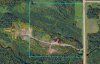
Of course the best thing for people like us is the aerial shots. It has the LIDAR relief and a couple aerial view options and then you can overlay that with the contours.
I uploaded a shot of the 40 I own to the west of the family farm. The orange lines are 10' contours and the yellow lines are 2'. The south side of the property and directly to the west is the gravel pit, so it is showing all of the gravel, rock and spoils piles that are still around. It seems like pretty good detail.

http://www.carltoncountygis.com/link/public/index.aspx
You can overlay with a ton of different items using the Legend in the upper left hand corner. It has the parcel property tax info, soils, lakes, streams, rivers, wetlands, school districts, zip codes and a bunch of other stuff.
Of course the best thing for people like us is the aerial shots. It has the LIDAR relief and a couple aerial view options and then you can overlay that with the contours.
I uploaded a shot of the 40 I own to the west of the family farm. The orange lines are 10' contours and the yellow lines are 2'. The south side of the property and directly to the west is the gravel pit, so it is showing all of the gravel, rock and spoils piles that are still around. It seems like pretty good detail.