CalTopo for detail work

BenA

5 year old buck +
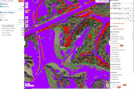
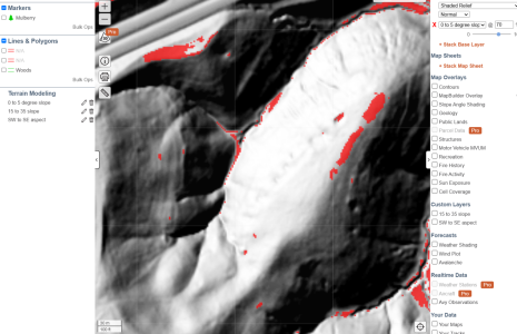
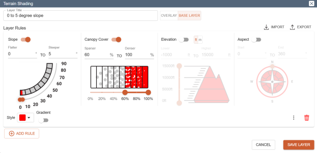
I was working on fine tuning some of my bedding, and like to use maps to start with. CalTopo has some great features. Terrain Shading allows you to color code areas based on factors such as degree of slope, canopy cover, elevation, and aspect. For example, I was wanting to narrow down some flat areas in my timber. I went to my area, changed the map to a Shaded Relief base layer (seems to work with any base layer you like), and added a terrain shading layer. For the layer, I chose to look at 0 to 5 degree slopes in areas with 50% or more canopy cover. To get more granular, I could narrow it down to certain elevations and slope aspects. I'm not as proficient with CalTopo as I'd like, but it seems pretty handy. You could map food plot locations, orchards, frost pockets, etc.
Screenshot 2025-03-25 144130.png

Screenshot 2025-03-25 144214.png
 
I’m not familiar with CalTopo. Can you use it on your phone?

Nm. Looks like you can to some degree but at a cost. Looks pretty user friendly. I’ve been doing those same things with QGIS but it’s taken a while to figure it all out.
 
Last edited:
I’m not familiar with CalTopo. Can you use it on your phone?

Nm. Looks like you can to some degree but at a cost. Looks pretty user friendly. I’ve been doing those same things with QGIS but it’s taken a while to figure it all out.
I have the free version on my pc and phone. My phone is an android. I'm not sure if the iPhone version is paid or not.
 
When you start combining and stacking layers, things like funnels really jump out at you. I told it to show flatter areas (0-10 degree slope) in purple and really steep drop-offs (30-90 degree slope) in red. I can confirm next to some of those larger red zones that there are some really good trails, and in many of the purple areas inside the woods, I have found beds. It's no replacement for stepping foot in certain areas, but it does highlight areas that could be improved or checked to make sure they're not blocked by downed trees or something. I haven't seen any of the hunting/mapping apps give this type of granularity.

Screenshot 2025-03-26 102420.png
 
Lidar is just starting to get more widespread in its use. Spartan forge has it and I’m sure OnX is developing it for their stuff too.

It’s an awesome e-scouting tool, especially for looking at accessibility issues on real estate listings.
 
Lidar is just starting to get more widespread in its use. Spartan forge has it and I’m sure OnX is developing it for their stuff too.

It’s an awesome e-scouting tool, especially for looking at accessibility issues on real estate listings.
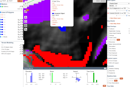
I've used LIDAR for a couple of years, but just recently began using the terrain modeling in CalTopo. I geek out on some of this, but I wanted to make the best use of my time in setting up some precision bedding locations. So, in this drawing, I am using it to check known bedding spots. I like the data it gives me. I did find a bed there, but other spots that may be right for bedding, I can go and check and fix them up. Like this blue spot, it shows that something should bed in that 700sqft area on a north or northwest wind. North of it is a larger bedding area in purple. There is a highly defined funnel just to the west of it that leads to a foodplot.

Screenshot 2025-03-26 162502.png
 
Have you played with Terran X on Onx? Other than the lack of toggling for: areas, pins and lines..... its pretty solid

I like aspects of CalTopo but struggle with it too. LiDar is awesome....but SpartanForge didn't wow me
 
Have you played with Terran X on Onx? Other than the lack of toggling for: areas, pins and lines..... its pretty solid

I like aspects of CalTopo but struggle with it too. LiDar is awesome....but SpartanForge didn't wow me
I haven't. I only have the free version. Can you tell it things like, "show me only the flat spots at the top third of all south facing slopes" like in CalTopo?
 
I think if/when OnX gets lines, areas and pin toggle in place on Terrain X theyll have a winner. Pretty big fan of their HD topo as well which has a LiDar like view. Not a fan boy or rep for them......or have anything against CalTopo. It seems the hunting map apps are due for a increase in services and quality though....
 
Back
Top