Mystery Drones - Who is flying them?

This is an interesting article published 2 days ago. The airport in question has 5 miles of airspace off limits to drones, but in recent days they have had a rash of drones "over the airport, over taxiways, [and] over runways." Some of these have been reported being "as big as cars."

Yet, nothing has been done about it. But, you can be comforted by the fact that they warn you not to shoot one down. That could be dangerous! 🥹

 
If you haven’t heard this yet it’s wild. Talks about the drones
 
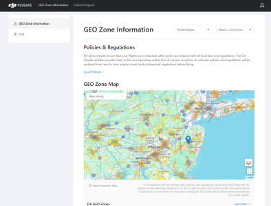
I'm not familiar with drones, but it looks like DJI has geo-fencing for their drones. Certain restrictions are in place over certain areas. The most restricted airspaces, prevent flight of their drones. Some zones, just pop up a warning on the screen. This website lets you put in an area and see the restrictions in place: https://fly-safe.dji.com/nfz/nfz-query

My question is how do I put a restricted zone over my property.

1736185398859.png
 
I'm not familiar with drones, but it looks like DJI has geo-fencing for their drones. Certain restrictions are in place over certain areas. The most restricted airspaces, prevent flight of their drones. Some zones, just pop up a warning on the screen. This website lets you put in an area and see the restrictions in place: https://fly-safe.dji.com/nfz/nfz-query

My question is how do I put a restricted zone over my property.

View attachment 72770
Donate enough to your congressman
 
If you haven’t heard this yet it’s wild. Talks about the drones

I watched that last night. I can not deny or confirm anything they said but. none of it would shock me..
 
I watched that last night. I can not deny or confirm anything they said but. none of it would shock me..
Right. It was definitely wild
 
My guess is it's some sort of commercial company. They are likely making some sort of mapping data for commercial sale. With drone delivery on the horizon, I'm guessing some kind of 3D map aids in delivery/autonomous piloting. Then the Amazons, Walmarts, etc of the world can be more accurate with deliveries.
That's very possible. My company bought a company in Poland that does 3D scanning with drones. They mainly do historic buildings. If it's a big infrastructure or commercial project they might want to keep it secretive until it's fully going to happen.
 
I'm not familiar with drones, but it looks like DJI has geo-fencing for their drones. Certain restrictions are in place over certain areas. The most restricted airspaces, prevent flight of their drones. Some zones, just pop up a warning on the screen. This website lets you put in an area and see the restrictions in place: https://fly-safe.dji.com/nfz/nfz-query

My question is how do I put a restricted zone over my property.

View attachment 72770
Some DJI GEO fences are around FAA restricted airspaces. Others are voluntarily over sites such as prisons, county jails, stadiums, etc. If you are a "Qualified Entity" as DJI refers to it, you can have them shut off. Public safety, for example....
 
I would think there must be some valuable parts on drones that could be sold for some extra money.
 
Crazy! We just had a giant drone (I think) fly over the place!
 
Really? That’s crazy, although I thought I heard one the other day, but could have been something else
 
I took a video of it but didn't get the phone to focus. The light pattern matched the one's in the news though and it didn't sound like the helicopters that usually fly over. I say "I think" it was a drone because nothing about it matched the helicopters we see here, but I do live under McConnell AFB air space and get to see lots of crazy stuff when they are training and whatnot. So who knows what it actually was.


Here's another video from the same spot. At the time I had no clue what I was looking at, but figure it was a training flight dumping flares.
 
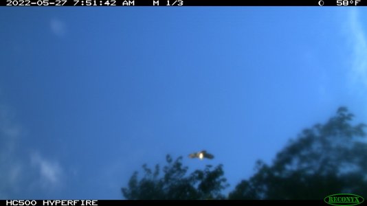
In May of 2022 we had a strong storm with 95 mph winds to hit my farm. I had several trees to go down, and one of them had a trail cam attached. After the fall the cam was pointed at the sky - looking over the top of a fence row. The cam took the following picture.
IMG_0145-ufo.jpeg
 
In May of 2022 we had a strong storm with 95 mph winds to hit my farm. I had several trees to go down, and one of them had a trail cam attached. After the fall the cam was pointed at the sky - looking over the top of a fence row. The cam took the following picture.
View attachment 72851
WTF are the chances of that?! Nope. No way. That is eerie! 😂
 
One of the planes fighting wildfires in California collided with a drone and is now grounded with a big hole in its wing. Link to story below.

 
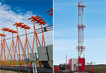
Military and large police forces have way of downing a drone without shooting it. Surprised you hear nothing about this. Basically disable it electroncally. Flying near an airport is not not collison damage from a drone, but can mess with the automated landing radio signals. Basically a analog electronic maps of where you are in relation to the airstrip.

Thats wreckless endargerment right there.

GBN_ILS_TopPhoto_2023.png
 
Now we have shotguns on drones. Should really be a big help with Turkey hunting

 
Back
Top