EngineerinSquid
Yearling... With promise
Hello everyone,
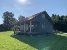
So a couple months ago I found a nice 40 acres in Northern Wisconsin that I have now official closed on. Now this land is far from perfect and I would like to make this thread kind of a documentation and journal of my journey into turning this into my own hunting retreat.
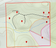
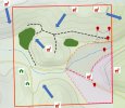
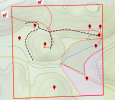
Now let's get started, above is a basic map of the property. Obviously names of roads and all that removed so I don’t get anyone snooping around after providing all this info. I’ll provide what pictures I have of the spots but will post updates when I get new or different pics. Points of Interest (POI) are numbered and are as follows: 1)Cabin spot #1 2)Foodplot #2 3)Treestand #1 4)Foodplot #1 5)Trail cam #1 6)Trail cam #2 7)Hilltop 8)Swamp #1 9) Swamp #2 10)Cliff
POI 1
This was actually the first spot I had picked out for a cabin on my first walkthrough of the property. It’s far off the road so no traffic noise, has a great view overlooking a drop off into the forest, one of the bigger flat spots on the property so should be easy to build. Current concerns are that there might be a natural spring filling a small ditch just off the build site, the distance from the road might make building a driveway and electrical expensive, and finally it is kinda in the middle of the majority of hunting ground on the property, as the two thin strips on the south edge of the property are undesirable to lure deer there. Also there is one of the few well defined deer tracks right next to the build site so might disrupt any deer currently residing on the property.
POI 2
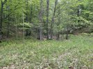
I found this spot on my second trip up to the property on a scouting trip. This was originally a planned building spot as it would leave the whole section of the property north of the road available to hunt, but after a visit from our road contractor and the septic contractor, the hill is too steep to get up to the site and would be super expensive to build a driveway up the side. As such this is most likely gonna be my second food plot site. The plan for this site would be to clear out most of the top of the hill similar to the clearing just south of my property. After the clear cut, I would plant some native tall grasses in the center and surround it with turkey attracting plants. Again most likely just to have a treestand up at first and maybe build an enclosed tower stand but this location would be less likely for that over the first foodplot.
POI 3
So this is kinda the only legal issue with the land as there is a treestand already here. Now it is under an open Managed Forest Law(MFL), for those not familiar it’s a law in Wisconsin that lets landowners have cheaper taxes for agreeing to properly manage their forest, so it is open to the public to hunt on and falls under public hunting rules until I close it, which will take effect at the start of next year. However, by public rules, tree stands are not allowed to be permanent and can only go up I believe a week before the opening of bow season. I plan on putting a notice on the treestand for 2 months and taking it down if it hasn’t been removed. And of course I’ll be putting up my own cause it is a pretty good spot. It will also be overlooking the spot of where I will be putting foodplot #1, but more on that in the next point.
POI 4
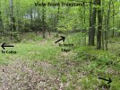
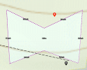
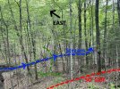
So this happens to be one of the largest semi-flat areas on the property and I would think it’d be perfect for a food plot except for one thing, the east edge is on a 40-50’ drop off into a valley. Now correct me if I’m wrong but there is a chance that deer may not make the climb up to that plot if they are entering the property through the ravine. Anyway currently planning on a hourglass shape with the two wide ends being oriented east-west depending on how my wind direction data pans out. This is important as my research suggests to set a treestand/blind/tower in the tree line where the hourglass kinda constricts.
POI 5&6
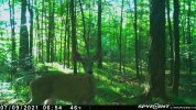
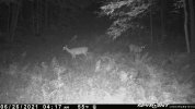
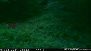
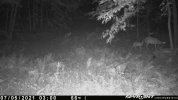
I will actually have 3 trail cams up from the start but I highlighted the two most important that I am placing. The first spot at #5 is going to be overlooking the foodplot. I picked spypoint cameras as I heard good reviews for them and the one at spot 5 will also be a solar trail cam. The next one at #6 is going to be overlooking a possible trail by the small creek as it enters the east end of the property.
POI 7
This hill is one of the tallest on the property and where I plan to plant a small food plot to attract primarily turkey. It has a nice flat top around 100’ in diameter and a nice clear trail to the top. It may also be a pretty good picnic spot as well.
POI 10
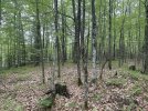
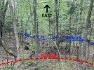
This is one of the most interesting features on the land. Only about 20 feet from the first tree stand, this is a drop off of about 30-40’ and overlooks the valley where the stream enters the property on the east side.
Well thanks for sticking in there and reading all of that. I don't have much else, as I did just close on the property so still gathering data and advice on how to proceed with different projects and potential improvements. I'm not trying to rush anything by any means but I am fairly young so I will have PLENTY of time to correct any miscalculations and screw ups that are bound to happen. Any advice is always appreciated and I would also like any tips or suggestions that could help guide me down a better path or train of thought. I do ask around in some of the other threads for advice as well so if you see one of those posts and can help please do. And the last thing I promise, if all you are going to do is reply with something non-constructive, harsh, or just generally bashing me for my lack of experience, please just don't post it, it'll save everyone some piece of mind as we are all here just to enjoy a shared hobby or two.
So a couple months ago I found a nice 40 acres in Northern Wisconsin that I have now official closed on. Now this land is far from perfect and I would like to make this thread kind of a documentation and journal of my journey into turning this into my own hunting retreat.

Now let's get started, above is a basic map of the property. Obviously names of roads and all that removed so I don’t get anyone snooping around after providing all this info. I’ll provide what pictures I have of the spots but will post updates when I get new or different pics. Points of Interest (POI) are numbered and are as follows: 1)Cabin spot #1 2)Foodplot #2 3)Treestand #1 4)Foodplot #1 5)Trail cam #1 6)Trail cam #2 7)Hilltop 8)Swamp #1 9) Swamp #2 10)Cliff
POI 1
This was actually the first spot I had picked out for a cabin on my first walkthrough of the property. It’s far off the road so no traffic noise, has a great view overlooking a drop off into the forest, one of the bigger flat spots on the property so should be easy to build. Current concerns are that there might be a natural spring filling a small ditch just off the build site, the distance from the road might make building a driveway and electrical expensive, and finally it is kinda in the middle of the majority of hunting ground on the property, as the two thin strips on the south edge of the property are undesirable to lure deer there. Also there is one of the few well defined deer tracks right next to the build site so might disrupt any deer currently residing on the property.

POI 2
I found this spot on my second trip up to the property on a scouting trip. This was originally a planned building spot as it would leave the whole section of the property north of the road available to hunt, but after a visit from our road contractor and the septic contractor, the hill is too steep to get up to the site and would be super expensive to build a driveway up the side. As such this is most likely gonna be my second food plot site. The plan for this site would be to clear out most of the top of the hill similar to the clearing just south of my property. After the clear cut, I would plant some native tall grasses in the center and surround it with turkey attracting plants. Again most likely just to have a treestand up at first and maybe build an enclosed tower stand but this location would be less likely for that over the first foodplot.
POI 3
So this is kinda the only legal issue with the land as there is a treestand already here. Now it is under an open Managed Forest Law(MFL), for those not familiar it’s a law in Wisconsin that lets landowners have cheaper taxes for agreeing to properly manage their forest, so it is open to the public to hunt on and falls under public hunting rules until I close it, which will take effect at the start of next year. However, by public rules, tree stands are not allowed to be permanent and can only go up I believe a week before the opening of bow season. I plan on putting a notice on the treestand for 2 months and taking it down if it hasn’t been removed. And of course I’ll be putting up my own cause it is a pretty good spot. It will also be overlooking the spot of where I will be putting foodplot #1, but more on that in the next point.

POI 4
So this happens to be one of the largest semi-flat areas on the property and I would think it’d be perfect for a food plot except for one thing, the east edge is on a 40-50’ drop off into a valley. Now correct me if I’m wrong but there is a chance that deer may not make the climb up to that plot if they are entering the property through the ravine. Anyway currently planning on a hourglass shape with the two wide ends being oriented east-west depending on how my wind direction data pans out. This is important as my research suggests to set a treestand/blind/tower in the tree line where the hourglass kinda constricts.

POI 5&6
I will actually have 3 trail cams up from the start but I highlighted the two most important that I am placing. The first spot at #5 is going to be overlooking the foodplot. I picked spypoint cameras as I heard good reviews for them and the one at spot 5 will also be a solar trail cam. The next one at #6 is going to be overlooking a possible trail by the small creek as it enters the east end of the property.
POI 7
This hill is one of the tallest on the property and where I plan to plant a small food plot to attract primarily turkey. It has a nice flat top around 100’ in diameter and a nice clear trail to the top. It may also be a pretty good picnic spot as well.

POI 10
This is one of the most interesting features on the land. Only about 20 feet from the first tree stand, this is a drop off of about 30-40’ and overlooks the valley where the stream enters the property on the east side.


Well thanks for sticking in there and reading all of that. I don't have much else, as I did just close on the property so still gathering data and advice on how to proceed with different projects and potential improvements. I'm not trying to rush anything by any means but I am fairly young so I will have PLENTY of time to correct any miscalculations and screw ups that are bound to happen. Any advice is always appreciated and I would also like any tips or suggestions that could help guide me down a better path or train of thought. I do ask around in some of the other threads for advice as well so if you see one of those posts and can help please do. And the last thing I promise, if all you are going to do is reply with something non-constructive, harsh, or just generally bashing me for my lack of experience, please just don't post it, it'll save everyone some piece of mind as we are all here just to enjoy a shared hobby or two.

