-
If you are posting pictures, and they aren't posting in the correct orientation, please flush your browser cache and try again.
Edge
Safari/iOS
Chrome
You are using an out of date browser. It may not display this or other websites correctly.
You should upgrade or use an alternative browser.
You should upgrade or use an alternative browser.
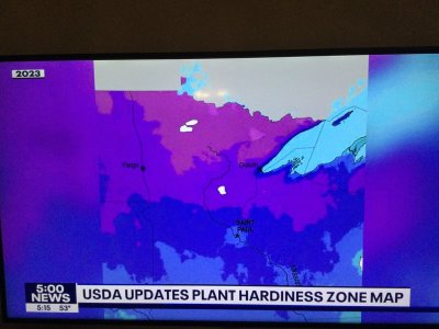
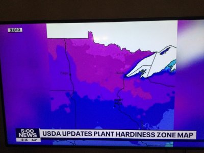
USDA zone map changes
- Thread starter AtomApple
- Start date
The Fishman
5 year old buck +
I saw this earlier today also. I went from 8b to 9. They don't seem to have an a and b anymore. The interesting thing I see in the new map for Minnesota is the heat island around Minneapolis/St Paul. Interesting that whatever measurements they were taking to derive the zones could pick up the heating effect from urbanization. I haven't looked at a nationwide map to see if this takes place elsewhere around urban areas.
silver_yummies
5 year old buck +
Map Downloads | USDA Plant Hardiness Zone Map
There is the link to US map and can get it by state also. I stayed 4B
FarmerDan
5 year old buck +
This version, and all things like this, are models of reality and not expected to mimic the real world precisely. It's likely the new version has greater granularity than the older versions.
The updated thirty-year temperature normals - or averages - ae used. Unfortunately there's no such thing as average weather. It's always too hot to too cold, to wet or too dry.
What happens at the edge is informative and may or may not influence your thinking. There will always be year-to-year variation.
A note from the documentation about heat sinks like urban areas:
Other notes for what went into determining the new zones you can find here:
https://planthardiness.ars.usda.gov/pages/map-creation
The updated thirty-year temperature normals - or averages - ae used. Unfortunately there's no such thing as average weather. It's always too hot to too cold, to wet or too dry.
What happens at the edge is informative and may or may not influence your thinking. There will always be year-to-year variation.
A note from the documentation about heat sinks like urban areas:
Finer Scale
Because the 2023 and 2012 maps were created digitally with GIS technology, they have a higher level of resolution and can show smaller areas of zone delineations than earlier maps. For example, cities tend to hold more heat because they encompass large areas of concrete and blacktop, so a city or town might be assigned to a zone warmer than the surrounding countryside. Higher elevations tend to be colder than surrounding lower areas, so the top of a mountain might be an area of cooler zones. A location near a large body of unfrozen water, especially downwind from prevailing breeze from that water, might provide milder winter weather and be in a warmer zone.Other notes for what went into determining the new zones you can find here:
https://planthardiness.ars.usda.gov/pages/map-creation
Native Hunter
5 year old buck +
I resent this. I identify as non-queer 6b. I’m not changing my identity affiliation because some metrosexual 4a wakes up with a hormone problem.
Wind Gypsy
5 year old buck +
Signature changed. Was on the 4a/3b border and now the 4b border is getting close. I'm not mad about it.
Wind Gypsy
5 year old buck +
Have to keep up with the global warming narrative. Winter is still a frigid bitch so I'll stick w/ previous maps.
haha what?
From USGS
Temperature updates to plant hardiness zones are not necessarily reflective of global climate change because of the highly variable nature of the extreme minimum temperature of the year, as well as the use of increasingly sophisticated mapping methods and the inclusion of data from more weather stations. Consequently, map developers involved in the project cautioned against attributing temperature updates made to some zones as reliable and accurate indicators of global climate change (which is usually based on trends in overall average temperatures recorded over long time periods).
First part was TIC. The second part was not.
Wind Gypsy
5 year old buck +
Makes sense. Definitely not going to be ordering less hardy trees now that this came out!First part was TIC. The second part was not.
Same here.Makes sense. Definitely not going to be ordering less hardy trees now that this came out!
bigboreblr
5 year old buck +
Camp up northern adirondacks went rrom 3b to 4a. At home, 1 mile from the hudson river i was a tiny dot of 6a around 5b. Now most of my county is 6a.
Doubt any decisions will be changed by me. Maybe my young granny smith has a chance for full ripeness. Pushing sundance and pristine sonewhat, not much though.
Doubt any decisions will be changed by me. Maybe my young granny smith has a chance for full ripeness. Pushing sundance and pristine sonewhat, not much though.
Teeder
5 year old buck +
Are you saying I should cancel my order of palm trees?Makes sense. Definitely not going to be ordering less hardy trees now that this came out!
4wanderingeyes
5 year old buck +
I went from 3b to 4a, but I know I’m the last 4 out of 5 years we have had -36 to -40. All except last winter, but we got a ton of snow last winter.
My thought is winter has been coming a couple weeks later, but staying a couple weeks later as well.
My thought is winter has been coming a couple weeks later, but staying a couple weeks later as well.
Similar threads
- Replies
- 17
- Views
- 1K


