All Things Habitat - Lets talk.....

This is a sample guest message. Register a free account today to become a member! Once signed in, you'll be able to participate on this site by adding your own topics and posts, as well as connect with other members through your own private inbox!

USDA Web Soil Survey

West Branch

5 year old buck +
Since we are always talking about soils and that sort of stuff I though it could be interesting to do a comparison of % wise for some of our local areas. If you use the USDA web soil survey you can select an area it tells you the different types for the local area.

What to do:
Go to this link and click start WSS: http://websoilsurvey.sc.egov.usda.gov/App/HomePage.htm
On the map zoom in to your local area by clicking and dragging a box on the area you want to zoom in.
Once you are close to your property use the AOI (area of interest) selection box to select the area.
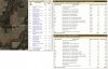
Once it loads click on the Soil Map tab near the top left of the window.
It should then list the different types of soils along with acres and %.

Here is a summary of the first one I did of the surrounding area centered around where we manage land.
~4,961 acres
41.6% - Ahmeek Loam
21.5% - Fine Sandy Loam (Multiple types)
2% - Fluvaquents (river flood plain)
Remainder is various muck and peat ground for swamps.

I did another one of pretty much just mine and my brothers property:
~600 acres
30.3% - Ahmeek Loam
37% - Fine Sandy Loam
5.6% - Fluvaquents (river flood plain)
Remainder is muck and peat

The loam and fine sandy loam are supposed to be ok farmland soil. The farm fields have had a lot of liming and I think most of their PH is at least 6.5. This should be good for the deer so they get better nutrients from the soil when eating the alfalfa and clover from what I understand. Our starting PH in most places is around 5 and sometimes less.

An airplane spreader to cover the woods with lime seems like a fun idea but probably not reasonable.
 
I think if you dig into the site and select the AOI (area of interest) you can find a color coded maps where it rates the ag potential of your place on a scale of 1 - 100.

Wish I would have consulted this resource earlier as some of my early endeavors were areas so full of rock they never turned into the 'ag' plots I wanted. Amazing how accurate the maps are.
 
It isn't the end all be all, but it definitely gives you a lot of knowledge that you wouldn't have otherwise and I find it very fun to play around on. Tons of interesting info on there.
 
Yup had to love reading that didn't you stu, especially coming up from the fertile grounds of Dane county. Did you happen to read any of the old abstracts that they have links to from back in the 20's and 30's written by the guys who actually did the field work on that ground, super interesting and those guys were spot on!
 
If you had any ladino on your parents place you were way further ahead of the curve than we ever got. But as I have said before, I just couldn't convince the old man to quit taking steel to that sand every year, at least up until a couple years before he sold the place. All that did was destroy the little OM we had in that soil and make it leach lime and fertilizer even worse than it already did. He would always listen to my uncle(who worked as a farmhand all of his life), who always farmed on the better soils in southern Juneau Co. towards La Valle and Wonewoc, where you could get away with moldboarding all the time.
 
Yup we made that mistake way back in 1980 when we cleared the area for the "south food plot". Run the "field" east to west to maximize sunlight for all the corn we were going to grow for the deer was the thought of the day. Again, the old man listening to farmers who had loam and sandy loam soils, I was 11 and didn't know any better at the time(not like he would have listened anyway). Bad thought on that Sahara-like soil.
 
I think if you dig into the site and select the AOI (area of interest) you can find a color coded maps where it rates the ag potential of your place on a scale of 1 - 100.

Wish I would have consulted this resource earlier as some of my early endeavors were areas so full of rock they never turned into the 'ag' plots I wanted. Amazing how accurate the maps are.

Yup, I saw the crop ratings too. The loam soils have a rating of 77 for 0-2% slopes and 65 for 2-12% slopes. The sandy loam soils are all 50.
 
soil map.jpg Lots of info on that site. Though I would show you all what I am working with. As you can see I got some decent farm ground - most of my plots are in areas that had once been crop fields before I implemented som CRP practices so my plots have real good fertility as well.
 

Attachments

  • soil map.jpg
    soil map.jpg
    708.4 KB · Views: 0
I put in about a 1 acre foodplot sometime around '08-'09..it was a rectangle but had some morning shade on the east side and afternoon shade on the west. Once I'd amended the soil with lime and a whole bunch of Stockosorb (no longer available from what I can determine) I could grow a halfway decent strip of a number of crops on the E and W side...but that middle section sure got burned up in dry years.

I did have buckwheat up to my hip a few times :)
We got many good crops of BW as well. Soys grew really good there also, till they got 6"-8" tall and got hoovered!:eek::mad: If we still had the place I was contemplating soys and e-fence for the whole area, just to see if they would have made it through the late July blast of drought we always seemed to get.

j-bird, you have nothing to worry about on those soils, I don't see the letters s-a-n-d in any of your soil descriptions. lol The areas with soils listed as "severely eroded" and "frequently flooded" are most likely your biggest challenge.
 
To be honest part of me wishes it was worse! I'm not a farmer, didn't come from farmers, don't plan to become a farmer. IF it was worse I would be able to make it all wildlife habitat, but the fact that it can produce a decent corn or soybean crop prevents me from doing that. The ag fields provide a nice supplemental income to the household and as such I can't remove acres from production without being able to provide some sort of financial offset (I looked into selling one of the kids or the wife gettin a job but the wife was against both of those - closest thing I could find was CRP programs and they have limits of 120' max from the previous field edge). Don't get me wrong - I know it helps the property retain its value, but when your a habitat guy in an area where ag crops are all over the place and cover is premium - I just can't help but dream of acres and acres of saplings and briars and just a tangled mess!
 
Top