General note on property tours

Steve Bartylla

5 year old buck +
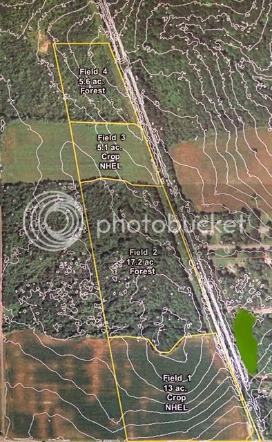
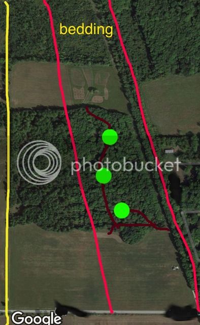
Can't speak for everyone, but I'd personally find even more value from property tours if it includes a topo along with the aerial. Topography just impacts things sooooooooooooooooooo much that I feel it'd greatly enhance their value.

I'm likely going to begin a more generically specific thread myself in a few weeks. Thinking I'll just take areas of properties and show what I've done and the results, good and bad. I did that a handful of times with the Grow em Big management show and tried to do the same with the book, figuring that if I can show enough areas/situations, odds are better that you guys will find something that applies to your grounds, at which point you can decide if it's worth a try or not.

In the mean time, if anyone is interested, I have a generic plan thread already here. It's the same one I had on QDMA:
http://www.habitat-talk.com/index.php?threads/sample-plan.355/

Still be happy to answer ?s on that, too....may even just make these new additions to that thread.
 
yeah...I'm always torn on which is easier to setup. On the one hand, ground with diverse topography more or less lays out your improvements for you, as you're going to lose way more often than not if you try fighting topography. On the flip side, flat ground tends to be more of a blank slate. The catch is that those subtle evaluation changes that don't appear on 10' topo maps can be significant in those flat pieces (more so than on ground with lots of topo).
 
Those 3 foot "humps" between those oxbows ARE likely your travel corridors through those bottoms. I know they sure were on our place, and the Little Yellow and Lemonweir are very similar in the way the bottomlands are laid out. I used to canoe both of them quiet extensively while shooting ducks as a kid and in a lot of places the only way you could tell which river you were floating was by how wide it was, given the Lil' Yellow is about half as wide as the Lemonweir, otherwise they are very much alike. Find the "main" trail through the hump(I know they are not always easy to find, but they are there) and "sidewalk" it while blockading the rest of the side trails and you will be off to a good start in directing predictable movements.
 
We had those parallel ridges as well, try your best to direct movement to a "common" exit into and out of the higher and lower areas. As an example, if you have 2 ridges that run east/west, run the trail on both ends of the north ridge off the south edge and direct the trail off the south ridge to the north side for entry and exit, kind of directing them to a common point in the "center" of the 2 ridges for access. They can wander where they want while on the ridge, but if they want on or off to other ground, they have to use the access points you created. I hope that makes sense the way I explained it? :confused:It is a full on guess as to which one they will travel on any given day though, I will agree with that.
 
You could try to direct those movements like shown below. Green double lines are heavy blockades, red lines are new "sidewalks" and show how they could direct movements to a common point at the end of 2 or more ridges.

4fa2684b2ecaffcd9233166de1add8ac.jpg

This is likely similar to what you are trying to do now, so I would encourage you to keep it up.
 
There's a lot of east-west movement where you have the blockades. I think tweaking that green area you showed to allow that east-west movement to continue while trying to narrow the funnel is what I'm attempting to do.

I think you and Whip are heading in the right general direction. It wouldn't be hard to add a bit more blockading to force the N/S & E/W traffic to all merge at one location, while creating a couple stands to cover the various winds. Without having more info, I'm hesitant to say much more than that, other than it seems like you and Whip are generally heading in the right direction. Now it's up to you to nail the specifics, while creating low impact, high odds stands in the process. When doing that, always pick your stands as the very first step and then make the improvements around them.
 
I agree Steve but my farm also literally has less than 20 foot change of elevation across 40 acres. I didn't even know my tractor and side by side are equipped with a brake pedal, never used 'em LOL I will add the topo from my SWCD/NRCS Conservation Plan to my tour for comic relief if nothing else.

(Formerly Stickbowcrafter from old forum)
 
Last edited:
Good to see I'm not the only one with flat ground. Looking forward to hearing what works at your places. Funnels in my country are timber corners connecting ag fields and fences. I have a few good corners but not much fencing, yet. I hear it can be pretty effective on semi-open flat ground like mine. Contour lines are 2 foot in elevation change. North woods is 10 year old clearcut regeneration and sanctuary. Secluded north field is where I put my orchard, chestnut grove and 3 acres of summer & fall food plots. I have a deer sidewalk going down the middle of the center woodlot, connecting the front ag field which is a commercial corn/soybean rotation. There are 3 kill plots along that sidewalk. My neighbor to the west does not hunt. I am the only one with permission but I stay out of there so it's essentially a big sanctuary. Prevailing wind is W/NW. I access all of my stands from the east boundary/power line to stands down wind of the sidewalk & kill plots.

9EB22FBB-AAB2-410F-B297-52B3DF712EED.jpg
 
Clearer, updated aerial showing my tree groves & food plots.

9E99788A-2DB5-4B30-B7D5-60E191A75D46.jpg
 
Yup, hunted all over that area my whole life and a 20' increase in elevation we call the "high ridge"!o_O LOL!
 
Funny to hear I have a hilly farm for a change. Where is dogghr? :p Of course I live near the Three Rivers in the foothills of the Alleghenies in SW PA so 20 feet is nothing but a treestand height...Going from home to my farm is like rolling off the big pile of bacon onto the pancake.
 
Weasel, even when the ground is flat as a pancake, which yours isn't, I personally find topos extremely helpful. They at least tell me that I'm not misreading the aerial and it is indeed that flat :D
 
I agree Steve

I knew where you were coming from Steve. Just having a little fun with how relative flat is to each region & person. I know many, many food plotters in the PA-OH-WV tri-state area and I get ribbed constantly about being so lucky to have the flattest ground. But with hills in the 1-3K range in the area, I guess an 18 foot elevation change over 40 acres is a pancake to them.

Picked up a couple of your books that I haven't read yet, enjoying them immensely.

A730ED52-F870-4F04-98D5-DF7DCAE0A30A.jpg
 
Thanks...If you come up with any ?s from either, don't hesitate to ask. I can't promise I'll know the answer or that I'm right on everything. I can promise that I'll tell you if I don't think I know and that I'll honestly believe what I say.
 
I'm NOT trying to push this down anyone's throats, but below is a link to the site I use (not mine and I get nothing from them.....I just find it helpful and thought maybe others would, as well). turn on the contours and you have the most current google earth imagery, with contours. I just do screen captures if I want to draw on them or use them in a thread.


https://mappingsupport.com/p/gmap4.php

P.S. it's free
 
^^^ I use it all the time, great resource!
 
I'm an ag enineer so we've got aerials/topos readily available and AutoCAD. Can really go crazy w/ plans and layouts. I checked that link out, we don't have any lines on our property. :)

Back when I had a real job, a portion of it was supporting/programming CADD software Kork (mapping software), Intergraph and AutoCAD were the 3 biggies we used/I worked with the most, with a few ESIRI products (not sure that's right....been a while. Whoever made ArcInfo). I can't even imagine how far those products have come in 15ish years. I imagine they dang near do the drafting for the users now.

P.S. Not that it matters at all, but for the last 5ish years of having a real job, mine was split between designing/implementing/maintaining computer networks for the various offices (they had around 10 back then) and programming/supporting the CADD software for the home office, while being a resource for those that did it in the outer offices.

Funny what a BS in Bio and minor in Cartography used to be able to get a person.....Started as a photogrammetrist (map making), transitioned to running the photogrammetry's editing & programming dept to networks and CADD support for the company, never having had a single networking class and 1 programming class that I got great at stealing other's programs, flunked every test. The world has changed soooo much since I got out of school. No way one could take that path with a BS in Bio anymore.
 
Last edited:
Top