Property Layout help

Prelude8626

5 year old buck +
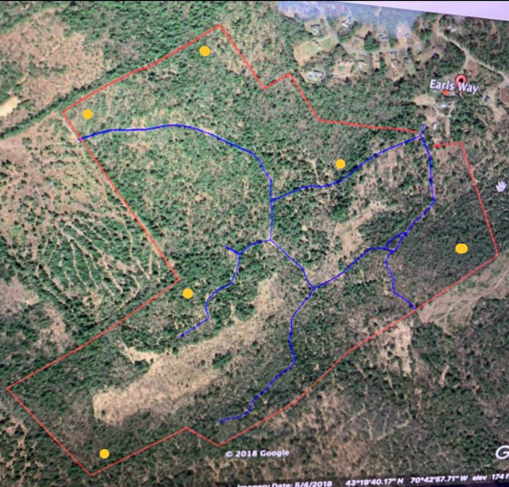
All. New to the habitat management game. I recently purchased 150 acres in Southern Maine and currently owned it for just about a year. I have put in two small plots that where is opening that just needed some clearing. The property consists of mixed pines and oaks (hasn’t been timbered in many years). There is also a fair amount of wetlands in the middle of the property. I would love to hear some input on how you all would lay out the property and what you would do. I have marked the property outlines and atv trails that where already there. Also how would you go about accessing the property. Any input would be great 476B7DE8-A9DD-47DB-8FEA-07B19B51550A.jpeg
 
Get somebody local on the ground with you if Maine offers that service.

In the meantime, tell us what you are managing for and what equipment you have.


Sent from my iPhone using Tapatalk
 
Take this for what it's worth cause it's very hard to give advice based on a single aerial photo, but it looks like you've already got some good habitat variety going on as well as some nice edge features. Are the blue lines the existing atv trails? If so, i would work on getting some better perimeter access because using those is going to alert game almost every time you come in.

Wetlands can be great natural habitat that provides both food and cover so I would leave those alone for the most part. If there is very little understory, you could do some hinge cutting to open up the canopy and you should get a bursting of new growth.

I really like that property line near the corner at the center of your pic. It appears to be a good funnel between the open area below and perhaps a recent timber harvest above? Definitely looks like a good ambush spot.
 
Just a generalized statement here.... if you can change your access routes to the outer most portions of the property you will more than likely have better luck actually holding deer on the property if that is your goal. I realize this may not be possible, but but lots of those ATV trails seem to go thru the heart of your property and will push deer away. I read somewhere that you should consider 100 yards off either side of a trail like that as a "disturbed" area. if you look at it that way - you can disturb less by keeping access to the perimeter of the property AND put half of that disturbance on the neighbors place as well.
 
Yes, I agree! It is on my list to try and access from the perimeters. It will need some cutting and time. Unfortunately the atv trials where in place prior. I would like to add more thermal bedding in the wetlands, fruit trees on the higher ground.
 
Get somebody local on the ground with you if Maine offers that service.

In the meantime, tell us what you are managing for and what equipment you have.


Sent from my iPhone using Tapatalk
Nobody in Maine offers such a service. I’ve been told I’m crazy to even try habitat work up here. I have contacted many outside sources but can’t justify spending multiple thousand dollars on something I should be able to do in time. All I currently have is a atv and utv. I do understand it is hard to just look at a area photo as well. Just wanted some generic input. At some point I will start a thread on the land tours and post more detailed pictures.
 
As for the existing ATV trails, you can let them grow in naturally as you clear new access trails around the perimeter. I've hunted in Maine a number of years - deer will use those older existing ATV trails to move around. Deer like easy travel rather than fight through heavy, thick brush. My guess is they already use those trails for ease / quickness of travel.

Concentrate on making new perimeter access trails. If north is the top of your pic, I'd use that short existing trail on the southeast side of your property that intersects with 2 other trails at a small triangle to access that area from the perimeter trail you make. Like Pinetag said above in post #3, that corner near what appears to be a logged area to the north would be a good place for deer travel. After making a perimeter trail, I think I'd cut a narrow trail from that corner to intersect the blue existing ATV trail near that corner. From past experience, deer seem to like checking out trail intersections. A lot of ground sniffing goes on in such places.

I would only hunt that property by foot travel - if it were me hunting it. ATV for retrieval of deer only, unless you have mobility problems. Sneak in - sneak out.
 
Before you get too far along with a plan... you need to understand what you have. Current bedding areas, deer trails, terrain features and the like will all dictate how you can best work with what you already have. Then you can evaluate what you need and what your goals are and develop a plan on how to get there. The tough part...is being brutally honest with what you have and what your expectations are (from personal experience on my end).
 
Before you get too far along with a plan... you need to understand what you have. Current bedding areas, deer trails, terrain features and the like will all dictate how you can best work with what you already have. Then you can evaluate what you need and what your goals are and develop a plan on how to get there. The tough part...is being brutally honest with what you have and what your expectations are (from personal experience on my end).

What I’ve noticed from hunting the property this year is that most deer sign goes the opposite way of the trail (the trials have been there for years). Ex. If the trail runs north to south, the deer go east to west. I don’t use any atv use from about September on, and saw deer just about every sit which is great for Maine. In terms of bedding they seem to stay in the grassy areas of the wetlands until it gets matted down from cold and snow.
 
From what I can tell it looks like zero AG source. Also you did not note where the food plots you created area. I personally would leave the ATV trails for the purpose of getting deer out And obviously for access as you begin your habitat projects. I wouldn’t use a single one of them for stand access however. It’s hard for guys to give toooo much input without a better understanding of what else surrounds the property (ie fields. Roads close by, AG ETC)
 
From what I can tell it looks like zero AG source. Also you did not note where the food plots you created area. I personally would leave the ATV trails for the purpose of getting deer out And obviously for access as you begin your habitat projects. I wouldn’t use a single one of them for stand access however. It’s hard for guys to give toooo much input without a better understanding of what else surrounds the property (ie fields. Roads close by, AG ETC)[/QUOTE

To answer your question there is hardly any AG in the general area. I would keep the ATV trials in place for access to work only. That was the plan and why I have two plots in the small openings (old log landings). Bottom pictures show the plots circled in red I also drew a yellow line showing a creek bottom that about 70 years a wide and goes up a ridge on both sides. That might be good access? FE58EE90-18F9-4FB5-9CD6-EEB0AD5CE6FE.jpeg

A542D475-628F-4035-9F2A-58C306C5B7A5.jpeg
 
Click to expand, post above. Messed it up with loading some how.
 
The top of that creek could be a great spot as well. Can you overlay a topo map onto the property photo?

Sent from my SM-G930V using Tapatalk
 
Not sure how to over lap one but this is pretty close. Maine use to have a great GIS program that I could do that on but the guy just retires and they won’t run the sight anymore.

28789A00-59D0-4896-8782-D367D6DAE9A9.jpeg
 
I would recommend something like this for stand setups. Can you only access from the eastern side where your trails come in? That's going to make it difficult to hunt/access with a wind coming from the NE or E.
e585f5dc589972070145144bd1677767.jpg


Sent from my SM-G930V using Tapatalk
 
That topo shows quite a few points that bucks should be relating to. If you don’t have On-X maps I would suggest getting it. You can then toggle back and forth between several maps with your property lines overplayed onto it. I also personably don’t like using a creek to access for the most part. It is it’s own edge and terrain feature in my opinion and deer will relate to it.
 
I would recommend something like this for stand setups. Can you only access from the eastern side where your trails come in? That's going to make it difficult to hunt/access with a wind coming from the NE or E.
e585f5dc589972070145144bd1677767.jpg


Sent from my SM-G930V using Tapatalk
At the moment, yes it’s the only entrance. We are in the process trying to get access at the top left.
 
That topo shows quite a few points that bucks should be relating to. If you don’t have On-X maps I would suggest getting it. You can then toggle back and forth between several maps with your property lines overplayed onto it. I also personably don’t like using a creek to access for the most part. It is it’s own edge and terrain feature in my opinion and deer will relate to it.

What points would you recommend? The actual points on the topo?
 
Bucks typically relate to a point. Specifically the ends of a point. If you have snow which being in Maine I’d imagine you do walk out to the ends of the points shown to you on that topo. Cover them throughly. I’d be willing to bet dependent of surrounding terrain and habitat features that your gonna find buck beds on some/most of them. If these point happen to be on any higher elevation vanatage point you’ll want to identify them. And keep them in mind as you layout your property design and stand access.
 
Also I’d say depending on the size and depth and everything else of that creek bottom, think about thermals when your deciding whether to make a stand in that area a morning vs evening. Could work in your favor when hunting on a questionable wind or it could burn you.
 
Top