Habitat plans - computer resources

Wind Gypsy

5 year old buck +
I'm trying to finalize a rough plan for what I want to do this year with the property and how much seed/etc i will need. I've messed with drawing it up on OnX and the county GIS to get rough acreage and dimensions but it got me curious if there is a better digital mouse trap for this.

Does anyone else do this and what tools do you use?
 
For measuring food plot sizes I use ACME Planimeter,
 
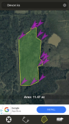
“Distance measure” app on my phone also does area measurements crazy handy app
 
D8CC40B7-1E78-422D-9A5B-30E4E25D5F8F.png
Next springs 8 acre planting plus last springs 3.5 acres should finish that area for mast tree plantings.
 
I‘ve been using HuntStand. It seems similar to OnX.
 
I use a combination. If I could combine them, I would. I use the download version of Google Earth, Huntstand, and my favorite, ArcGIS.com.
 
I've had a hell of a time trying to find recent aerial photos of my property. The latest I can find is on pasda.psu. It at least shows since I've timbered, which is now over 5 years ago but not since I put in my main plot 3 years ago.
 
I've had a hell of a time trying to find recent aerial photos of my property. The latest I can find is on pasda.psu. It at least shows since I've timbered, which is now over 5 years ago but not since I put in my main plot 3 years ago.
If you used google earth pro on a computer, it sometimes defaults to an image from 1985. If you click on that date indicator in the lower left corner, a slide bar pops up in the upper right corner, that will allow you to select another date. Depending on your location you can probably get up to 2021 images.
 
I've had a hell of a time trying to find recent aerial photos of my property. The latest I can find is on pasda.psu. It at least shows since I've timbered, which is now over 5 years ago but not since I put in my main plot 3 years ago.
NAIP - National Agricultural Imagery Program. New imagery is acquired on a 3 to 5 year cycle at the state level.1638461948525.png


1638461948525.png
 
If you used google earth pro on a computer, it sometimes defaults to an image from 1985. If you click on that date indicator in the lower left corner, a slide bar pops up in the upper right corner, that will allow you to select another date. Depending on your location you can probably get up to 2021 images.
I have google earth pro on work computer. 2016 is the most recent image. They don't like to fly over me for some reason.
 
NAIP - National Agricultural Imagery Program. New imagery is acquired on a 3 to 5 year cycle at the state level.View attachment 38959


View attachment 38959
Thanks Dan. How do you access it? I'm on the NAIP site and it sends me to arcgis but the aerials on that are old as well. Do I need to access through the state?
 
Thanks Dan. How do you access it? I'm on the NAIP site and it sends me to arcgis but the aerials on that are old as well. Do I need to access through the state?
Depends what you are willing to do...and by that I mean how hard do you want to look for an application that serves NAIP? NAIP is built for use in ESRI's ArcGIS applications. There once was a free dumbed-down version available. There's free GIS software. QGIS I think. You might find the most recent NAIP in some of the NRCS applications like WebSoilSurvey. USGS has a viewer that uses NAIP. Don't know how up to date it is with imagery. There's lots of opportunity but sometime you need to turnover a lot of rocks to find it.

Here's to the FSA Aerial Photography field office:
https://www.fsa.usda.gov/programs-and-services/aerial-photography/imagery-programs/naip-imagery/

USGS:
https://www.usgs.gov/core-science-systems/national-geospatial-program/national-map

Pennsylvania Spatial Data Access:

I know it's a lot! There's a lot out there...I, personally, am a ArcGIS guy. Google Earth is my lite GIS!

Oh! And how could I forget!
https://datagateway.nrcs.usda.gov/

You'll find download access to NAIP here, but you still need an application to read it. Maybe Google Earth?
Thanks Dan.

The PA spatial data access is the one I have found the most recent imagery on. I'll check the others out. We have a GIS department at my company. Maybe I'll see if they can send me something.

Thanks again.
 
Google Earth Pro is really fantastic.
Thanks, that's what I did. Need to watch some more tutorials to learn some more tricks.
 
Thanks, that's what I did. Need to watch some more tutorials to learn some more tricks.
You know it’ll calculate acreage, too, right?
 
You know it’ll calculate acreage, too, right?
Yep. To clarify, I used google earth after creating this thread. Pretty slick. I need to learn how to input property boundaries but mine is a simple square 40 so i can draw it very close.
 
MotionX-GPS is an iPhone app I use that very seamlessly uploads points and tracks from your phone to email and then to Google Earth.

I also took the time to overlay my land’s survey in GE. Pushed and pulled corners of that screenshot for too long to get every line just the right length. Haha
 
Last edited:
Top